


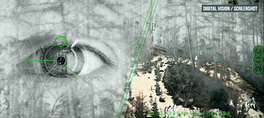
After a useful digital zoom implemented in October, two brand new features were activated in FusionSight: a Global Navigation Satellite System (GNSS) and snapshots recording. Since the hardware dedicated to these features was already included, both FusionSight weight and design remain the same. To keep acquisition and maintenance costs as low as possible, the FusionSight team selected a powerful civil GNSS feature. It is compatible with the American GPS, the Russian GLONASS, the European Galileo, the Chinese BeiDou, and also with all Satellite-Based Augmentation Systems (SBAS). Six digit grade coordinates are now displayed in real time on the internal screen, giving the user important information on their location. During operations, users can communicate these coordinates for support if facing potential threats. Coordinates are also useful to mark a specific location of interest. Last but not least, the joint use of FusionSight and a laser range finder allow users to estimate the location of targets more precisely.
The first duty of Homeland Security is to prevent, as far as possible, criminal or terrorist actions. Therefore, a large part of the job is to lead observation and surveillance operations. As criminal activities often occur at night, Homeland Security teams use the Night Vision Device to accomplish their operations. Before interventions, these committed forces need to record evidence for legal reasons. As a consequence, image recording capability is a requirement for the Night Vision Device. That is the reason why Bertin’s team decided to implement a snapshot feature in FusionSight. As for FusionSight as a whole, its zoom has been developed to meet user needs. It works like any commercial camera: the user simply pushes a button to take a snapshot of what they are looking at. The icing on the cake is that every single snapshot taken is actually saved into a commercial SD card in four images: one image for the three modes of FusionSight (Thermal, Low Light and Fusion), and one screenshot. Users then insert the SD card into the SD slot of a computer, in order to browse saved images and to select the most appropriate ones. Finally and to comply with legal requirements, the whole images are tagged with GPS coordinates, date and hour.